The GeoMol15 Temperature Model
01.04.2019 | Swiss Geological Survey
What is it about?
The GeoMol15 Temperature Model forms part of the ongoing expansion of the GeoMol 3D geological model, not only in terms of horizon and fault surfaces, but also in terms of geological properties. The subsurface distribution of temperature is an example of such a property. It is one of the main parameters used in assessing the geothermal resource potential of the Swiss Molasse Basin.
As such, the model shows the regional distribution of temperature in 3D, not only as a block model, but also as temperatures on selected surfaces. These surfaces represent seismic marker horizons, fixed depths below ground level or isotherms. The block model has a resolution of 1000x1000x100 m3 and is derived from a FE-method temperature model (Geowatt AG, 2015), which is based primarily on 31 vertical temperature profiles and the horizon surfaces from the Seismic Atlas of the Swiss Molasse Basin (2012). The FE temperature modelling method assumes conductive heat flow only and does not consider convective heat flow.
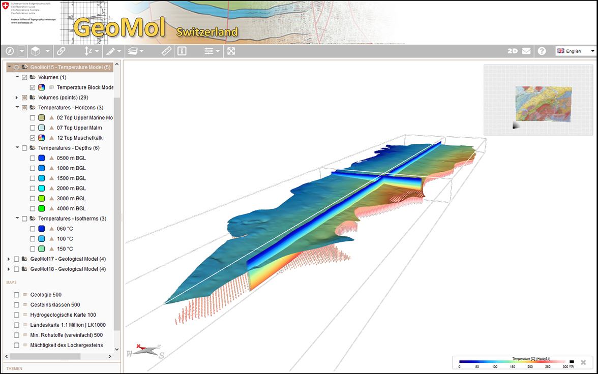
Fig. 1 of 3:
GeoMol viewer – A 3D view of the GeoMol15 temperature model using slices, points and a temperature surface.
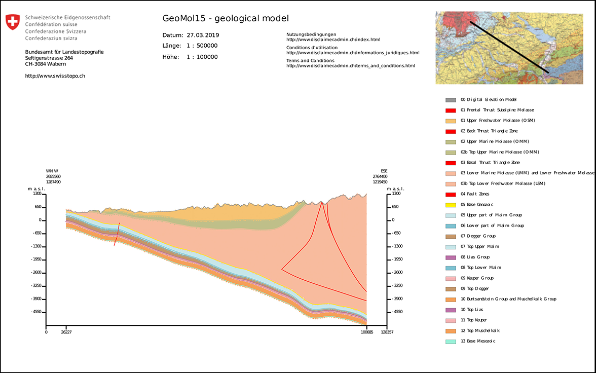
Fig. 2 of 3:
GeoMol viewer – A profile through the GeoMol15 geological model.
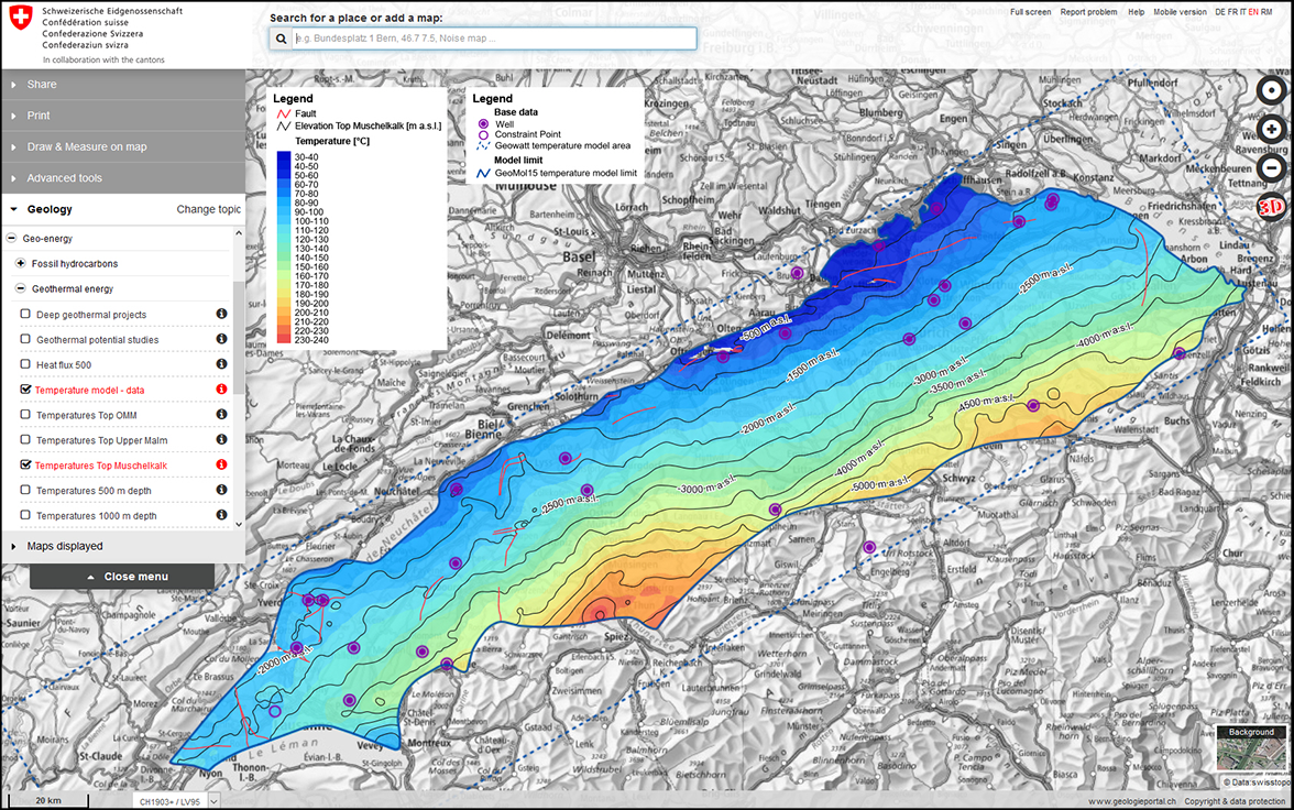
Fig. 3 of 3:
Mapviewer – A map showing the temperature distribution, elevation and location of faults on the Top Muschelkalk.
Where is it available?
Both the 3D model and its derived 2D maps are available for online viewing and interrogation. In 3D, the GeoMol15 temperature model – as well as the corresponding geological model – are available via the GeoMol viewer (Fig. 1). Here, the modelled temperature distribution is available as a block model as well as 12 temperature surfaces for selected horizons, at fixed depths below ground level and isotherms. In addition, profiles and fictitious wells can be generated at any location within the model (Fig. 2). In 2D, a data coverage map and 12 temperature maps – corresponding to the above-mentioned temperature surfaces of the 3D model – are available through the map viewer of the federal geoportal map.geo.admin.ch, e.g. under the topic «Geology» (Fig. 3 and map below).
Subsurface temperatures in map.geo.admin.ch
How can it be used for exploiting geothermal energy?
Geothermal energy is a renewable resource that can be used for heating and cooling applications by extracting heat from, respectively injecting excess heat into, the underground. If it is extracted at reservoir temperatures above ca. 120 °C, electricity can be generated as well. Thanks to its potential to substitute fossil fuels and nuclear power for energy production, geothermal energy is an integral part of the national Energy Strategy 2050. In this context, between 2016 and 2018, the Federal Office of Energy mandated the Federal Office of Topography swisstopo to create an information platform (Project GeoTherm) for publishing relevant data for the development of geothermal energy. The GeoMol15 Temperature Model also forms an extension of the GeoTherm dataset.
The online model components are intended for use by national and local authorities, consulting companies, universities and the general public for various tasks, e.g.:
- to communicate the national and regional geothermal potential of the subsurface
- as an input to roughly determine areas with a theoretical potential for electricity or heat production from certain geological layers
- to define boundary conditions for more detailed local temperature models using other data and methods.
The long-term plan is to update the model and the derived maps when new deep geothermal well data are available. In the short to medium term, new temperature surfaces and maps can be extracted from the 3D model and published as the need arises.